
Terri and I take a break before attempting the steep climb back up to the main road. On the steepest section, Terri took a spill and crashed the bike (this is crash #3 for Terri... the last one she broke a toe! I have had a couple of near-misses... but we always where our helmets).
The scooters we have are Chinese made, and seem to be able to take a beating, as we are not gentle on them, running around the island and some of the roughest roads, and crashing them now and then...
We next went to Ushi Cross Point, the most northern point on the island. There is a road (that we have seen from the air, but doesn't show up on a map) that runs from that point, along the eastern shoreline, to the Blow Hole.

At the end of the road, there are some monuments and a prayer chapel


Just to the east of this site is the road that we wanted to explore

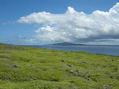
There were great views of Saipan all along this road

In some places the road turned inland for a ways, and then returned to the shoreline
We discovered yet another monument that had been built to honor people who had been lost at sea off Tinian

There was a little grove of trees to give shade, and then a short trail out to the monument


As we stood admiring the view, Terri noticed that a large cargo ship was heading toward Saipan. It made me wonder what the Japanese must have felt as they watched all the US ships arrive at these islands, and then started to pound the islands with shells before launching the invasion... It would have been easy to see what the Americans were going to do, and yet no way to stop them! Just glad it wasn't me...

This is a view of the small grove of trees that was planted to shade any groups coming to visit the small memorial

The road once again heading inland for a while, before following the shoreline almost directly south


We finally arrived at the Blow Hole. This is a view looking south from the Blow Hole, towards Long Beach
And this is the view looking north towards Saipan

The Blow Hole was rather quiet today, as the waves were very calm. And the water that usually pooled and filled all the depressions was either low or completely absent.

This was about the best it could do today. Most days the funnel of water would fill the screen!

So we headed back home, taking Broadway south to the Village

Once home, and hot, we decided to go swimming at Taga beach. On our way we noticed a large family of cats...with thier own watch-dog!?
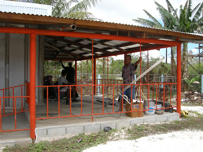
I finally discovered what they were building near the top of our street, next to the four-plex that is also being built: they tell me it is going to be a Pizza Parlor! Woo Hoo!

The workers tell me that they hope to open sometime next month. So, Monster Pizza at the Dynasty Casino is going to have some competition? As good as the pizza is at Dynasty, this new place better bring their A-game!

Taga beach was nice and calm, and beautiful as ever. It is funny that more people don't swim here--there is really nothing to it, in fact, Terri and I don't really swim, we just float! You can stand straight-up in the water, without moving your arms and legs to swim, and your head will still be well above water (of course, some might say I carry more bouyancy than most...).
As on most days here on Tinian, Terri and I had the beach all to ourselves...

On our way home, we saw two men working on the roof of the new barbeque shack (you know me and anyone on a roof... I have to know what they are doing!).

See if you can see the cameleon on this stump...

This one is a little easier to see! Terri seems to like the cameleons around our apartment, for some reason. She likes them better than the geckos... perhaps because they stay outside?

They do get mad if you bother them, though...
It was a great day of fun and adventure!
 There was a great view of Saipan from the top of the hill by the Tinian airport
 There was a great view of Saipan from the top of the hill by the Tinian airport


No comments:
Post a Comment